Explore Our Latest News & Articles
Heading northbound or southbound on the Chesapeake Bay opens up numerous opportunities for discovery on its western and eastern shores. Take some time to explore the area from the Pocomoke River to Kiptopeke and enjoy the beauty of the wetlands and abundant wildlife around you. Dedicate a couple of stops at the quaint coastal towns along the way, filled with history & charm.

Pocomoke River
(View in Waterway Guide Explorer)
Starting at Pocomoke Sound and winding inland, this river cuts a path through extensive marshes and cypress swamps filled with rich vegetation and an array of wildlife to please any nature lover. There is no sign of civilization for miles and there is not a sound to be heard except the rumble of your engine. You are seeing the river perhaps the way Capt. John Smith saw it 400 years ago. The long and winding Pocomoke River runs almost all the way across the Delaware-Maryland-Virginia (Delmarva) Peninsula and is navigable 26 miles upstream to Snow Hill, MD.
Navigation & Dockage: The entrance to the river is marked and requires careful attention, especially through the shallow areas know as The Muds. The river remains unmarked in certain stretches due to its depth, but caution is advised as shoaling can occur. Up the river, the Pocomoke City Municipal Marina has fixed dock space both east and west of the Market Street Bridge. A about 7 miles farther upriver, Pocomoke River State Park offers dockage (to 40 feet) at Shad Landing Marina.
NOTE: Aside from Shad Landing Marina, gas is scarce and there is no diesel here. There is also no room for anchoring.

Onancock Creek
(View in Waterway Guide Explorer)
Onancock (pronounced "oh-NANN-kock") Creek lies almost 20 nm southwest of the mouth of the Pocomoke River and about 5 nm southeast of Watts Island. This deep and winding tributary offers both scenic beauty and a gateway to town conveniences. The creek provides an inviting route for boaters, leading to the Town of Onancock, rich in culinary offerings and local charm.
Dockage & Anchorage: Onancock Wharf and Marina provide slips with essential amenities and a courtesy car. Anchorage in the harbor is available but requires keeping a distance from the commercial docks to avoid interfering with the operational traffic.

Cape Charles
(View in Waterway Guide Explorer)
The coastal town of Cape Charles is a popular destination for cruisers with its appealing mix of good restaurants, shops, and marine services. It's an ideal stopover before crossing the bay to Hampton Roads.
Dockage & Anchorage: Cape Charles offers a range of docking options, from a resort-style marina at Kings Creek to the convenient town harbor. While anchorage is seen in the outer harbor, it is not recommended due to traffic. Instead, visit the nearby Kiptopeke Beach, noting it is suitable for day stops but challenging for overnight stays due to changing conditions and the presence of crab pots.

Kiptopeke Beach
(View in Waterway Guide Explorer)
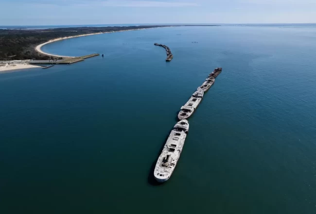
Just 5 miles southeast of the Cape Charles harbor entrance is Kiptopeke State Park on the Bay shoreline and just a few miles north of the Bay Bridge Tunnel. This is the final resting place for nine concrete ships constructed during World War II providing a fascinating look back at the history of the area.
Anchorage/Considerations: It is deep right up to the shore but you will find more wind and wave protection closer to the ships at Kiptopeke Beach State Park. However, during the prevailing summer southeast breezes, it can become uncomfortable due to swells from the Atlantic Ocean, and rough in southwesterly winds. The area is also filled with crab pots, making it challenging for larger boats to anchor without encountering issues. Overnight stays should be carefully considered due to quickly changing conditions.


