Log In
/-78.235445022583,33.920909838837,12/500x250?access_token=pk.eyJ1Ijoid2F0ZXJ3YXlndWlkZSIsImEiOiJGRmM1RDdzIn0.Wya5yV5QEqbz0-fct8zyIA)
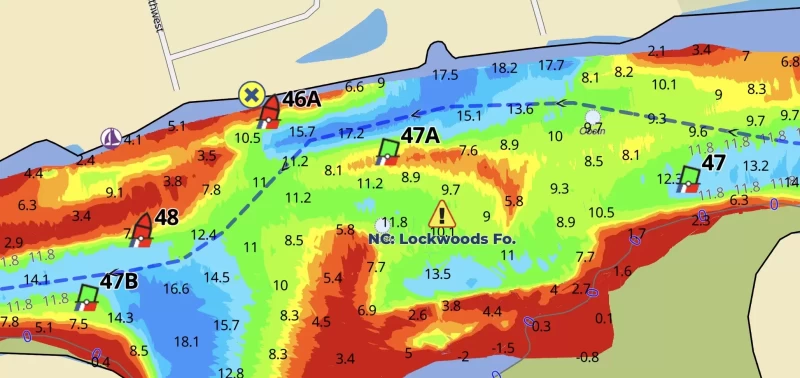
NC: Lockwoods Folly, shoaling MM 321.5
- Date Reported: Nov 12, 2025
- Reporter: Bob423
- Source: User
- Description:
Update: The blue track has been changed to the shore route for 8 MLLW
The red track shown on the previous alerts has been deleted. The Coast Guard only buoys the shore route so the blue track represents the official Coast Guard track now. When Lockwoods Folly is dredged in the future, the buoys will not mark the straight through path. It's the shore route all the time now.
USACE = US Army Corps of Engineers
ATONs = Aids TO Navigation such as buoys and daymarks
Aqua Map = a navigation app for Apple and Android devices
Bob423 Long Track = blue dotted line
How to download tracks - Lat / Lon: N 33° 55.255' / W 078° 14.127'
DISCLAIMER: Waterway Guide Media provides Navigation Alerts as a resource for planning purposes only and does not warrant the information included in the postings as accurate. Advice and descriptions contained in the alerts are not for navigation.
5 Boater Comments
-
Comment by: Hubert Hopkins, Aurora, on Oct 29, 2025
Vessel Type: Power
LOA: 42'
Draft: 4.0'I can confirm that there is 5 to 6 ft at low tide on the straight through track between greens 47 and 47B. It was confusing following the Aqua Maps chart because the straight through line was more prominent and the buoys 47A and 46A were not seen over on the shore route. Caution is needed here as it often is in Lockwoods Folly.
View location on the Waterway Guide Explorer
-
Comment by: George Rod Nelson on Apr 11, 2025
Vessel Type: Power
LOA: 40'
Draft: 4.5'Came through this area on 4/10 about 2 hours before low tide. A dredge is sitting on the shoal marked by G47a. Followed Bob423 track closely and saw no less than 12ft. There is a yellow can to the south of 47a which I believe is associated with the dredge operation and not an ATON.
View location on the Waterway Guide Explorer
-
Comment by: Cam and Jennifer, Viatori, on Apr 9, 2025
Vessel Type: Power
LOA: 47'
Draft: 4.0'We came through today at 11:00a EST, and saw shallows of 6.4' under the hull. Depths were mostly above 10' under the hull. Wilko was in the channel dreging today.
View location on the Waterway Guide Explorer
-
Comment by: Hubert Hopkins, Aurora, on Oct 29, 2024
Vessel Type: Power
LOA: 42'
Draft: 4.0'The channel markers have been moved to reflect the Bob423 track as of Oct 29, 2024.
View location on the Waterway Guide Explorer
-
Comment by: Susan Cole on Apr 9, 2024
Vessel Type: Power
LOA: 42'
Draft: 4.0'Atons have been moved showing straight channel through.
View location on the Waterway Guide Explorer


